I have known Charles for many years as we encountered each other several times when the leading producers lured us to Champagne to launch a new vintage. Above all, we became good friends when he was part of the champagne jury that I led during the Decanter World Wine Awards in London for several years.
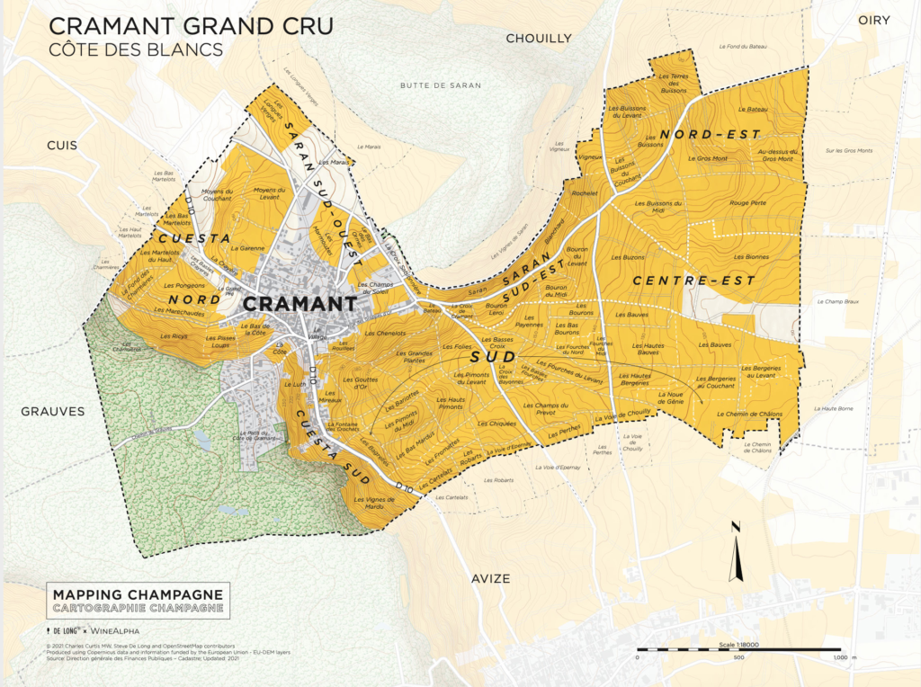
It’s with great expectation that I got the first map in the series MAPPING CHAMPAGNE: CARTOGRAPHIE CHAMPAGNE in my hand – the beautiful village of Cramant.
BACKGROUND France’s famous wine regions have been extensively mapped and documented throughout its history, more than any other wine-producing nation. Oddly enough, Champagne, arguably its most famous region, has not received the same attention: the great wine cartographer Louis Larmat produced the only detailed maps of Champagne in the 1940s. Subsequent maps have been much more abridged. Benoit France, Larmat’s modern peer, has produced only summary maps of the region, without any vineyard details.
THE MAPS A new series of maps by Steve De Long and Charles Curtis MW addresses this with a modern update and expansion of the pioneering work of Larmat. They are to be released in a series of village maps, starting with the northern limit of the Côte des Blancs, Chouilly Grand Cru. Each map is accompanied by a bilingual French and English booklet that provides a tour of the village terroir and their unique wines, a complete list of lieux-dits planted (or partly planted) in the commune, and a directory of their winemakers. The entire set of Côte des Blancs maps will be available this fall, including a large map of the main portion of the Côte des Blancs including all its grand crus.
THE AREA More than doubling in area from 1946 to 1975, the postwar expansion of the vineyards made any vineyard map obsolete soon after completion. Although Champagne’s emphasis has always been on blending and not individual sites, terroir has always played an important role, from the now-defunct Echelle des Crus system of rating villages to winemakers simply knowing where the best plots are and their unique characteristics, which is now taking on increasing importance.
THE BOOKLET
- In the first section there is an explanation of the specific terroir of the village [both in English & French].
- In section umber two there’s a complete list of lieux-dits planted (or partly planted) in the commune.
- In section three there’s a directory of their winemakers.
- In section four there’s info of the village such as planting by grace variety, total hectares, number of vineyard owners etc.
- In section five there’s a glossary.
Master of Wine Charles Curtis (author of Vintage Champagne: 1899 to 2019) and prolific wine cartographer Steve De Long have embarked on this much-needed update of the maps of the Champagne region, which are being released in printed and electronic versions that are available here: https://www.delongwine.com/ as well as on Amazon: https://www.amazon.com/delong